A TRAVELER'S GUIDE TO STATES YOU WOULDN'T THINK OF VACATIONING TO OR A PIRATE'S LIFE
- CHAPTER NINE-
JEAN LAFITTE
*singing*
Yo ho, yo ho, a pirate's life for meWe pillage, we plunder, we rifle, and lootDrink up, me 'earties, yo hoWe kidnap and ravage and don't give a hootDrink up me 'earties, yo hoYo ho, yo ho, a pirate's life for meWe extort, we pilfer, we filch, and sackDrink up, me 'earties, yo hoMaraud and embezzle, and even high-jackDrink up, me 'earties, yo hoYo ho, yo ho, a pirate's life for meWe kindle and char, inflame and igniteDrink up, me 'earties, yo hoWe burn up the city, we're really a frightDrink up, me 'earties, yo hoWe're rascals, scoundrels, villans, and knavesDrink up, me 'earties, yo hoWe're devils and black sheep, really bad eggsDrink up, me 'earties, yo hoYo ho, yo ho, a pirate's life for meWe're beggars and blighters, ne'er-do-well cadsDrink up, me 'earties, yo hoAye, but we're loved by our mommies and dadsDrink up, me 'earties, yo ho
Tis a pirate's life here at the GUIDE and as part of our STATES WE WOULDN'T THINK WOULD BE A TOURIST DESTINATION, we present PIRATES!!!
I turned on the TV and there, as if by magic, was the story of the pirate Jean Lafitte and I decided, SWEET!!
New chapter for the guide!!!!
WHO WAS JEAN LAFITTE?
AS STOLEN BY WIKIPEDIA - Jean Lafitte (c. 1780 – c. 1823) was a Frenchpirate and privateer in the Gulf of Mexico in the early 19th century. He and his elder brother, Pierre, spelled their last name Laffite, but English-language documents of the time used "Lafitte". The latter has become the common spelling in the United States, including for places named after him.[1]Lafitte is believed to have been born either in Basque-France or the French colony of Saint-Domingue. By 1805, he operated a warehouse in New Orleans to help disperse the goods smuggled by his brother Pierre Lafitte. After the United States government passed the Embargo Act of 1807, the Lafittes moved their operations to an island in Barataria Bay, Louisiana. By 1810, their new portwas very successful; the Lafittes had a profitable smuggling operation and also started to engage in piracy. Though Lafitte warned the other Baratarians of a possible military attack on their base of operations, a United States naval force successfully invaded in September 1814 and captured most of Lafitte's fleet. Later, in return for a legal pardon for the smugglers, Lafitte and his comrades helped General Andrew Jackson defend New Orleans from the British in the final battle of the War of 1812. The Lafittes became spies for the Spanish during theMexican War of Independenceand moved toGalveston Island, Texas, where they developed a pirate colony they calledCampeche. Lafitte continued attacking merchant ships as a pirate around Central American ports until he died circa 1823, trying to capture Spanish vessels. Speculation about his life and death continues among historians.
A TRAVELER'S GUIDE TO STATES YOU WOULDN'T THINK OF VACATIONING TO
- CHAPTER EIGHT-
ILLINOIS
Illinois state motto - We aren't going to tell you, come find out yourself!! Or State Sovereignty, National Union
Illinois State Capitol - Springfield (yes, THAT Springfield!!!)
Here we are, the state of Illinois, Land of Lincoln, Chicago (which we will ignore because you already know about the great city of Chicago but not much else!)
So where to begin!
"How about stealing something from Google!"
Sounds like a plan!!!
STOLEN FROM GOOGLE:
Illinois is a midwestern state bordering Indiana in the east and the Mississippi River in the west. Nicknamed "the Prairie State," it's marked by farmland, forests, rolling hills and wetlands. Chicago, one of the largest cities in the U.S, is in the northeast on the shores of Lake Michigan. It’s famous for its skyscrapers, such as sleek, 1,451-ft. Willis Tower and the neo-Gothic Tribune Tower.
"Sounds like a piece of heaven!!"
It sure does!! And there's more to it than just Chicago, there's flat lands as far as the eyes can see.
If you squint hard enough, you'll be able to see the sea!!
I kid, maybe!
STUFF TO SEE AND DO IN ILLINOIS (besides watching paint dry and the grass grow!)
Go check out https://www.enjoyillinois.com/ to find out more about Illinois; tell them The Blogger sent you and get a punch in the nose!!
Orchards in Illinois!!!
During harvest season, take your family out in the country to one of Illinois' many orchards, all filled with fun and games, fresh goodies, and U-pick apples and pumpkins.
Yes, there's orchards!!! Nummy fruits all for the picking
Quirky places to stay like tree houses and other fun places.
Find quirky places to stay in Illinois, from treehouses to yurt villages to a school bus turned solar-powered home.
Watch the grass grow and paint dry.
Yes!! It's a thing; don't believe me, go Google!! SEE!!???? Even the people living in Illinois are outside watching that stuff!!!
And now you can too!!! Get on the bus and head to Illinois and tell them, THE BLOGGER SENT ME!!!
And they'll punch you in the nose!!!!
TRAVEL ILLINOIS AND UH, OTHER PLACES TOO!!!
Travel well, travel light and come back here for more suggestions than you can shake a stick at!!!
A TRAVELER'S GUIDE TO STATES YOU WOULDN'T THINK OF VACATIONING TO
- CHAPTER SEVEN-
ARKANSAS
State motto: DON'T LOOK AT US!!! (Just kidding!!!!) "Regnat Populus" "What does that mean?" WE WILL KILL YOU IF YOU LOOK AT US!! Just kidding, it means, "The People Rule"
"And what does that mean?"
We have no idea!!!!
So here we are again, the greatest travel guide you didn't think you needed and well, we're not even sure why we're even writing it other than boredom and a map of the United States of America.
"As you already know, my wife wanted to go on vacation but I was like, I JUST WANNA GO SOMEPLACE DIFFERENT!!! And so we went to Google and found you!! What's an Arkansas??"
"Bill Clinton!!"
"Uh, I think we'll pass!!!"
"No, no, hold on, it's more than just the Clintons!! So much more!!! Here's what Google says about it!!!"
Capital (a forgotten piece of information from those other states we've already posted!! Sorry!!!) - Little Rock (motto - DON'T BEND OVER IN FRONT OF BILL CLINTON!!!)
AS STOLEN FROM GOOGLE -
Arkansas is a southern U.S. state bordering the Mississippi River. It's known for its abundant park and wilderness areas, with terrain encompassing mountains, caves, rivers and hot springs. The rugged Ozarks region in its northwest has hiking trails and limestone caves such as Blanchard Springs Caverns. Its capital, Little Rock, hosts the Clinton Presidential Center, housing Bill Clinton’s presidential archives.
THE OFFICIAL TOURISM OFFICE (in case you want a real tourism site and not just some bored guy's idea of a tourism site!! "But we love you Mr. Blogger!!!!" Thanks!!!!) : https://www.arkansas.com/
"And limestone caves??" Wifey throws in. "Lets go!!!"
"Take me with!! TAKE ME WITH!!!"
There's also lakes, rivers, water front cabins where in a passionate moment and the breaking of a condom you can tell your kids they were conceived in the same state that Bill Clinton's illegitimate children were made!!!
"ENOUGH WITH THE CLINTON JOKES!!!! You had us at cabin!!"
Of course, there's shopping!! So much shopping, that, after you're done, you won't want to shop anymore.
You'll literally SHOP TILL YOU DROP and won't want to stop!!! (I made a rhyme!!!!)
"What if I did enough shopping back in the early 1980s?? And I'm hungry???"
Then Arkansas is for you!!!
There's eats!!!
Tons of eats!!!
So much eats, you won't want to get up and do anything else after you're done eating!!"
"Can we eat in a cave or a large orange?"
You sure can!! You sure can!!!
"Well we're set!!! But what cities are there??!'
Cities?? DOES ARKANSAS HAVE THE CITIES!!!! (Click here for a huge list of cities and towns here!!!! )
Of course, there's Little Rock but well, here's just a few as stolen from the above site!!!
ADONA
Adona, Arkansas is located in Perry County. Nearby Little Rock and North Little Rock form the vibrant heart of Arkansas. The two cities and their neighboring towns comprise a metropolitan area of some 500,000 people in central Arkansas. This metropolis, as well as Conway, Searcy, and Cabot, and nearby cities in the central region offer a cosmopolitan mix of historic attractions, imaginative shopping opportunities, fine dining, nightlife and creative arts and fine hotels.
A grand collection of museums offers something for every taste – from art to history to aerospace. And the Quapaw Quarter of restored 19th-century homes is one of the country's finest examples of bringing an older neighborhood back to life through adaptive reuse.
Be sure to visit the new River Market in Little Rock for tastes of exotic cuisines and the freshest of produce from nearby farms in season. Extensive park systems in both cities provide the chance to play golf or tennis, fish for lunkers in the Arkansas River or on area lakes, hike leafy trails, talk to the animals in the park-like Little Rock zoo or picnic in beautiful natural settings. Central Arkansas is an ideal staging area for your Natural State vacation. Its big city tempo exists side by side with small-town charm. Discover Central Arkansas's winning ways for yourself.
ALTUS
The small, rural town of Altus is a distinctive and important aspect of Arkansas's history and culture. Altus preserves the heritage of German-Swiss immigrants and the art of wine making. Its downtown pays tribute to its coal mining history while offering visitors unique shopping and dining experiences in a classic, small downtown square setting.
In the Arkansas River Valley rich soil gives life to vineyards. Thousands of visitors stop to savor Arkansas's award-winning wines, tour its wineries and soak up the history of Arkansas Wine Country each year. Six wineries – Post Winery, Wiederkehr Wine Cellars, Mount Bethel Winery, Chateau Aux Arc, Dionysys Wine and Brew, and Neumeier Winery - now operate in the Altus area. Each offers free tours and operates tasting rooms. Some offer extra amenities such as a gift shop, a restaurant, an RV park, or a bed and breakfast inn.
In nearby Paris, Cowie Wine Cellars offers tours and tastings and is home to the Arkansas Historic Wine Museum, which preserves the viticultural past of The Natural State with winemaking artifacts and biographical histories of winemakers. The pastoral landscape of the region, boasts more than 120 years of viticultural history with some historic vineyards run by the fourth and fifth generation descendants of the original wine families.
Arkansas is the oldest and largest grape juice and wine producing state in the southern United States. Drawn by the Benedictine of Subiaco Abbey, a colony of German-Swiss immigrants settled in the foothills of the Ozark Mountains and began growing grapes in the 1870s at Altus in Franklin County. These early viticulturalists found great potential for grape production in this Arkansas River Valley region with mountains and valleys, and well-draining sandy soil that closely resembled the microclimates that had for centuries nurtured Europe's great wines.
In addition to wine, coal mining is a part of Altus' history. The centerpiece of the square is a beautiful city park containing memorials to coal mining memorial and veterans. In the late 20s and 30s, the coal mines played a very important part of the economy of Altus and a thorough recitation of the region's coal mining history can be found at the town's Heritage House Museum. Surrounding the park are shops containing antiques, collectibles and crafts, as well as restaurants. Enjoy a meal at one of several restaurants on Altus' historic square, such as Kelt's.
Two area churches also attract visitors. In Altus, St. Mary's Catholic Church is a 1902 Roman Basilical style church known for its paintings and ornate gold leaf work. It is listed on the National Register of Historic Places. About 25 minutes away, the Benedictine of Subiaco draws visitors to experience the beauty and solitude of its grounds, comprised of a sprawling campus of impressive sandstone buildings and a Romanesque-style Abbey Church set amid extensive farmland, finely manicured lawns, gardens and vineyards.
Other prime areas for exploring within an hour's drive are Mt. Magazine State Park, Lake Dardanelle State Park, the Ozark National Forest, and the Mulberry River. Mt. Magazine State Park, the highest point in Arkansas, rises out of the Arkansas River Valley to an elevation of 2,753 feet above mean sea level. The mountain's eight scenic overlooks have traditionally enticed visitors up the mountain. It also offers hang gliding, rappelling, camping, trails, and an extensive butterfly population. A visitor center contains exhibits and a gift shop, while a lodge offers a restaurant, swimming pool, meeting space and upscale rooms. Thirteen cabins flank the lodge.
For added value and fun, plan a tour to the Altus region during one of the annual wine festivals that offers more than a taste of delicious wine in a celebratory atmosphere, but also an experience of family heritage and tradition. Lodging can be found at several bed and breakfast inns and RV parks with traditional hotels just minutes away atOzarkandClarksville. Or book a night at the bed and breakfast inn atCowie Wine Cellarsabout 25 minutes away in nearbyParis. Altus is five miles south of Interstate 40, exit 41, on Ark. 186. Fort Smith is about one hour west,Fayettevilleis about one hour north, andLittle Rockis about two hours east.
MAGNOLIA
The Columbia County seat, about 2.5 hours from Little Rock is a charming southwest Arkansas town with a quaint courthouse square. The town proudly displays its heritage with colorful murals on buildings around the square. Numerous shops and restaurants ringing the courthouse await visitors. Also highlighting the square are the stately trees which give the town its name. Founded in 1909, Southern Arkansas University, a liberal arts college that calls Magnolia home, offers a varied calendar of events and tours of its 658-acre Agricultural and Horticultural Farm. At 3,000 acres, Lake Columbia is one of the largest Arkansas Game and Fish Commission impoundments in South Arkansas and is popular with both anglers and outdoor enthusiasts. The Magnolia Blossom Festival and World's Championship Steak Cook-off draws thousands of visitors each May.
At nearby McNeil, Logoly State Park is an environmental-education park that is popular with school groups and scout troops. Twelve miles south of town is the tiny community of Emerson which every June hosts the World's Championship Rotary Tiller Race and Purplehull Pea Festival.
Natural resources have played an important role in the region. Cotton was the cash crop in the nineteenth century; timber, oil, and gas in the mid-twentieth century; and later bromine became instrumental. The first inhabitants of the area were Native Americans. Settlement of the area began after Arkansas achieved statehood in 1836, when small communities were formed. Columbia County was created from portions of Lafayette, Hempstead, Ouachita, and Union counties in 1852. The county seat, Magnolia, was incorporated three years later.
Columbia is the only one of Arkansas's seventy-five counties not situated on a river so transportation was an issue for the county. For early travelers, the county's creeks and bayous were too narrow and shallow to support water traffic. The arrival of railroads created a dependable transportation option. It was not until the construction of the St. Louis, Arkansas and Texas Railroad in 1882 that the first cotton was shipped from the county by railcar. Cut off from the planned railroad, leaders in Magnolia resolved to have a spur line built to the city. The branch was completed the next year. The Louisiana and North West Railroad was built between Magnolia and points in Louisiana in 1899. Magnolia grew steadily after World War II. Cotton remained the chief crop into the early twentieth century, and offshoots from the cotton industry provided the area with its earliest trade and manufacturing base. An important example was the Magnolia Cotton Mill in 1928, the first textile mill in southwest Arkansas.
The discovery of the Magnolia Oil Field ten years later was another monumental turn for the town.
This quickly led to the development of an oil and gas exploration industry within the county. While the importance of oil and gas drilling declined steadily, a new natural resources industry arrived in the mid-1960s as chemical companies discovered the high bromine content of brine, an element used in many chemical and manufacturing processes, located thousands of feet beneath the earth's surface. Columbia and Union counties sit on one of the largest brine reserves in the world. Timber also holds an important role in the area.
And so many other cities we just can't cover them all!!!! So are you packed yet?
"YES WE ARE!!"
So there you go, Arkansas!!!
Travel well, travel often, and remember, DON'T BEND OVER IN FRONT OF BILL CLINTON!!!! Have a great trip!!!
So it is 12:30 in the morning, August 31st, 2018, and I've done published five chapters of THE GUIDE (the only guide you'll ever need!!! BUHAHAHAHAHAHAHA!!!!!) and I have decided to write another entry.
The first entry; CHAPTER ONE : IOWA, has hit the feed as a published feed so, I decided to hit the Google and discover some more one on one tourist attractions that seem like they'd be cool places to visit while visiting the great state of Iowa.
The Villisca Ax Murder House jumped out at me from a list on a site.
I was trying to find some abandoned bridges or highways, a blog to go along with my still, at this time, unpublished blog on Route 66 and there it was.
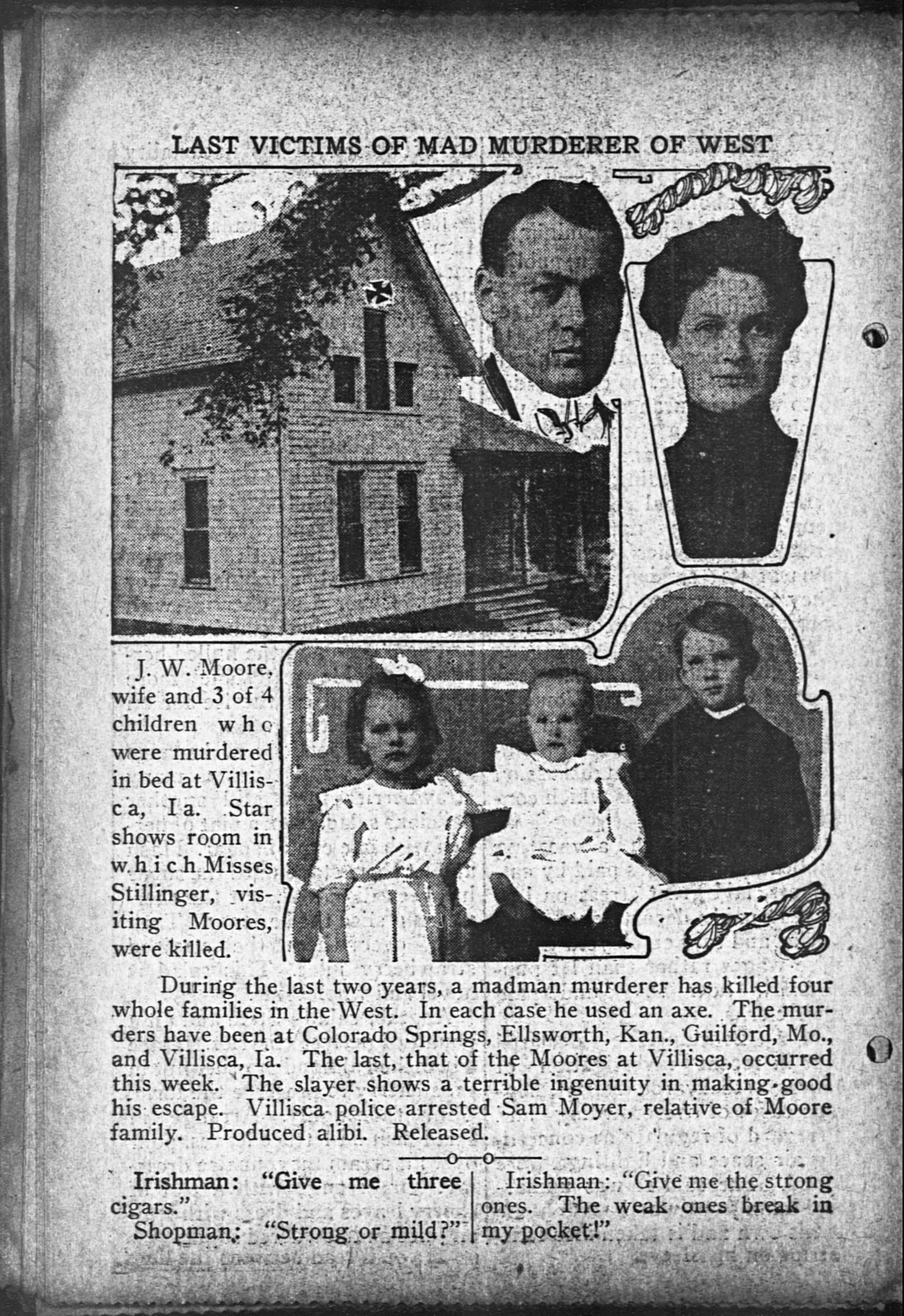
June 10th, 1912 - Villisca Iowa - a house owned by J.B. and Sarah Moore sits quietly, but not too quietly, as on this evening, 8 people will be murdered - two adults and six children.
Six family members of the Moore family and two house guests were murdered; severe head wounds from an ax was the cause of death for all eight.
The murders are still unsolved.
(click on image for bigger version at Wikipedia. Click here for a ton more details on this murder)
As with any thing as violent, there is now the stories of bumps in the night, doors opening on their own and other ghostly activities as reported by visitors to the house.
If you are brave enough, you too can visit this home and maybe you will get to experience a visit by the spirits in an attempt to solve this horrendous case.
Address for this location: It can be found at 508 E 2nd St, Villisca, IA 50864 and tours can be done; check their website for details.
AS STOLEN FROM THE OFFICIAL WEBSITE = Go check them out for the whole story along with more facts then you can shake a stick at!!
June 10, 1912 Villisca, Iowa
On a quiet residential street in this small town sits an old white frame house. On a dark evening, the absence of lights and sounds are the first indication to visitors that this house is different from the other homes that surround it.
Upon closer inspection, you'll notice it's doors and windows are tightly closed and covered. An outhouse in the backyard suggests that this house does not occupy a place in the 21st century but somehow belongs in another era or another story.
A weather-beaten sign hanging from the decrepit front porch warns rather than welcomes.
It is the "Murder House"
The walls still protect the identity of the murderer or murderers who bludgeoned to death the entire family of Josiah Moore and two overnight guests on June 10,1912. Almost 97 years later, her secret continues to draw many visitors to her door.
A TRAVELER'S GUIDE TO ROUTES, HIGHWAYS AND WHATEVER ELSE FLOATS THE BOAT
- CHAPTER FIVE-
ROUTE 66
I know what you're thinking!
"What the hell? Route 66??? That's not a state!!! That's a highway!!"
And welcome to the guide you didn't realize you needed till right now.
"The hell!!! But okay, we'll listen, you got us with the Nat King Cole song --- Route 66!!!" your wife says, settling down into the nice soft chair.
"So, what the hell is Route 66 and should I care?" Hubby asks.
"Give us the Wikipedia answer!!" Wifey says, knowing full well now the procedures of this travel guide.
And we are here not to disappoint!
AS STOLEN FROM THE WIKIPEDIA
U.S. Route 66 (US 66 or Route 66), also known as the Will Rogers Highway, the Main Street of America or the Mother Road, was one of the original highways within the U.S. Highway System. US 66 was established on November 11, 1926, with road signs erected the following year.[4] The highway, which became one of the most famous roads in the United States, originally ran from Chicago, Illinois, through Missouri, Kansas, Oklahoma, Texas, New Mexico, and Arizona before ending in Santa Monica, California, near Los Angeles, covering a total of 2,448 miles (3,940 km).[5] It was recognized in popular culture by both the hit song "(Get Your Kicks on) Route 66" and the Route 66 television show in the 1960s.
US 66 served as a primary route for those who migrated west, especially during the Dust Bowl of the 1930s, and the road supported the economies of the communities through which it passed. People doing business along the route became prosperous due to the growing popularity of the highway, and those same people later fought to keep the highway alive in the face of the growing threat of being bypassed by the new Interstate Highway System.
US 66 underwent many improvements and realignments over its lifetime, and it was officially removed from the United States Highway System in 1985,[2] after it had been replaced in its entirety by segments of the Interstate Highway System. Portions of the road that passed through Illinois, Missouri, New Mexico, and Arizona have been designated a National Scenic Byway of the name "Historic Route 66", which is returning to some maps.[6][7] Several states have adopted significant bypassed sections of the former US 66 into the state road network as State Route 66.
STATES THAT ROUTE 66 MADE ITS WAY THROUGH (and some of it can still be traveled nowadays all the way, including some states (as noted with links) already covered by this wonderful and grand guide!!) Some notes are stolen from the Wikipedia entry about Route 66 and can be found above at the link provided!
I've used the famous 'Quote' function of Blogger to note these stolen sections. ENJOY!!!
California
(The sign of US 66's western terminus at the Santa Monica Pier)
California probably will not make THE GUIDE as a separate entry but that may change or individual tourist spots that some people do not know about maybe entered as case by case (aka The Blogger discovers that Fresno, California has a sub sandwich shop that just makes you want to travel to Fresno, California for a sub!!
US 66 had its western terminus in California, and covered 315 miles (507 km) in the state.[55] The terminus was located at the Pacific Coast Highway, then US 101 Alternate and now SR 1, in Santa Monica, California. The highway ran through major cities such as Santa Monica, Los Angeles, and San Bernardino. San Bernardino also contains one of the two surviving Wigwam Motels along US 66. The highway had major intersections with US 101 in Hollywood, I-5 in Los Angeles, I-15, and I-40 in Barstow, and US 95 in Needles. It also ran concurrent to I-40 at California's very eastern end.[56]
(US 66 marker on the corner of Navajo Boulevard and Hopi Drive in Holbrook, AZ)
Another possible entry into THE GUIDE unless The Blogger decides not to because his ADD made him spend the lot of his time in New Jersey which as we all know, is highly possible!!
In Arizona, the highway originally covered 401 miles (645 km) in the state. Along much of the way, US 66 paralleled I-40. It entered across the Topock Gorge, passing through the ghost town of Oatman along the way to Kingman.[57] Between Kingman and Seligman, the route is still signed as SR 66. Notably, just between Seligman and Flagstaff, Williams was the last point on US 66 to be bypassed by an Interstate. Holbrook also contains one of the two surviving Wigwam Motels on the route.[58]
Added to the possible states to be included in full details of future entries to THE GUIDE. Highly probably as a state entry on its own because well, it's New Mexico and I feel it needs an entry!!
US 66 covered 380 miles (610 km) in the state and passed through many Indian reservations in the western half of New Mexico.[59] East of those reservations, the highway passed through Albuquerque, Santa Fe, and Las Vegas. As in Arizona, in New Mexico, U.S. 66 paralleled I-40.[60]
Probably will not be added to THE GUIDE except as a mention here. Everyone knows Texas is a whole different country even though it's a state. This refusal to give Texas its own entry in the guide may be reversed by future council meetings of The Great Guide Council of Fort Wayne, Indiana!
Okay, we may do an entry for such wonders as Paris, Texas as well as any other cities and spots we discover on our travels through time and space known as the Internet!!
(Pavement markings indicating the historic alignment of Route 66)
Entry already scheduled to be published on September 2nd, 2018. Oklahoma definitely rocks!!
(Note - Wikipedia puts Oklahoma and Kansas together as Kansas only had three cities on the Route!)
The highway covered 267 miles (430 km) in Oklahoma. Today, it is marked by I-40 west of Oklahoma City, and SH-66 east of there. After entering at Texola, US 66 passed through Sayre, and Elk City before entering Oklahoma City.[62] Beyond Oklahoma City, the highway passed through Edmond on its way to Tulsa. Past there, US 66 passed through northeastern Oklahoma before entering Kansas where it covered only 13.2 miles (21.2 km).[63] Only three towns are located on the route in Kansas: Galena, Riverton and Baxter Springs.
Everyone knows Chicago but Illinois is more than just that so it definitely will be entered into THE GUILD. Because well, it just seems like a rocking place to go and hide a body, oops, I mean, travel to for a tourist destination.


Lafitte is believed to have been born either in Basque-France or the French colony of Saint-Domingue. By 1805, he operated a warehouse in New Orleans to help disperse the goods smuggled by his brother Pierre Lafitte. After the United States government passed the Embargo Act of 1807, the Lafittes moved their operations to an island in Barataria Bay, Louisiana. By 1810, their new portwas very successful; the Lafittes had a profitable smuggling operation and also started to engage in piracy.